
Publicité
Conference on 30th March 2013 Port-Louis Floods: highlights
Par

Partager cet article
Conference on 30th March 2013 Port-Louis Floods: highlights

On Friday 28th March 2014, the multimedia (video) team of La Sentinelle Ltd, held a viewing of a video documentary titled ‘Port-Louis sous les eaux’ at the Municipality of Port-Louis. Parents of victims, students, journalists, municipal counselors and members of the civil society were among the 60 participants. Here are the keypoints of the debate.
On Friday 28th March 2014, the multimedia (video) team of La Sentinelle Ltd, held a viewing of a video documentary titled ‘Port-Louis sous les eaux’ at the Municipality of Port-Louis. This was followed by a debate led by the opinions of a panel of experts. The event, co-hosted by the municipality of Port-Louis and La Sentinelle, was organized in commemoration of the first anniversary of the deadly floods that engulfed the capital on 30th March 2013. Parents of victims, students, journalists, municipal counselors and members of the civil society were among the 60 participants.
The purpose of the debate was to: (i) analyse what caused Port-Louis to flood, (ii) evaluate the measures which have been adopted so far to address the dangers of flooding in Port-Louis, and (iii) discuss what should be done in order to prevent a reoccurrence of a similar flooding experience.
The following speakers intervened on the occasion:
1.Mrs Dorine Chukowry, Mayor of Port-Louis
2.Mrs Gina Bonne, Environment and Climate change mission in-charge at the Indian Ocean Commission
3.Mr Iqbal Bhugun, Meteorological scientist
4.Miss Karuna Rana, Co-founder of Small Island Developing States Youth AIMS Hub
5.Mr Nand Sooredoo, Hydraulic civil engineer
At the start of the meeting, a one-minute silence was observed in memory of the floods’ victims. The facts, observations and recommendations evoked during this debate addressed the Port-Louis floods under the earlier identified three thematic. The debate was moderated by Nad Sivaramen, Director of Publications at La Sentinelle Ltd.
Key points of the debate
Causes of flooding in Port-Louis:
•Going by its topography, Mauritius, should logically not be prone to floods. However, unplanned construction works, which started back under the period of British colonization even, have made us conducive to flood.
•In various places across Mauritius, the natural courses of water have been altered in order to make way for infrastructure. Figure 1.1 shows how, historically, a creek at Candos was diverted to accommodate a footpath.
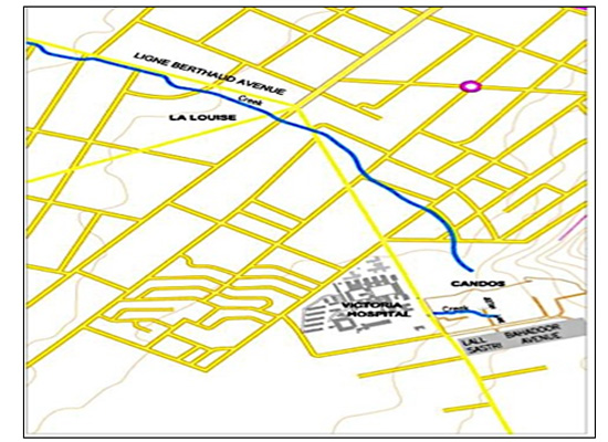
Figure 1.1: Diversion of natural course of water at Candos during British times
•Figures 1.2 and 1.3 respectively, show how unplanned infrastructural development at Pailles, Les Guibies has perverted the natural course of water. Figure 1.2 locates the erstwhile natural drain amidst sugar plantations. Rainwater absorbed by the soil ran through these natural watercourses. However, as demonstrated by the contrasting figure 1.3, unplanned ad-hoc drains have replaced these natural watercourses. These have been built along the roads. It is also to be noted that these drains do not lead to any outlet for an eventual evacuation of water.
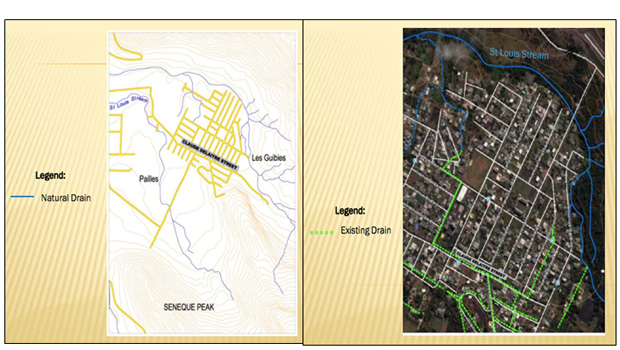
Figure
1.2: Erstwhile natural watercourse 1.3: Present replacement drainage system
•At several places in Port-Louis, inhabitants have constructed over the drains located at their entrances. These block out the water flowing at the road level to flow into the drains.
See Figure 1.4 for an example.
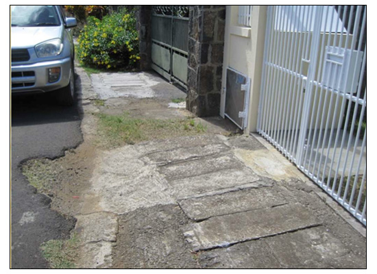
Figure 1.4: Drains blocked at the entrance of a house in Port Louis
•In the particular case of Canal Dayot, in trying to please lobbies, the canal has been incapacitated to face situations of flooding. The natural breadth of Canal Dayot is 30m. However, land which formed part of the riverbed was sold off to individuals and only a reserve of 8 meters was retained to accommodate the canal water. However, recently, at the time of the reconstruction of the boundaries of Canal Dayot, the breath of the bed was extended to 18m, as authorities tried to strike a balance between safeguarding the private ownership of the adjacent properties and flood risk mitigation. Figure 1.5 shows the progressive modifications to the riverbed of Canal Dayot. It also points out the plots of land forming part of the riverbed which have been sold off to individuals.
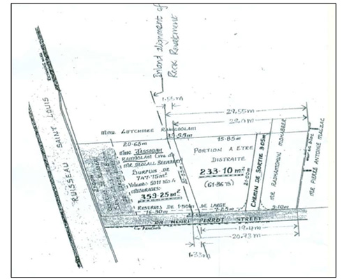
Figure 1.5: Canal Dayot’s reorganisation plan
Measures adopted so far to address the dangers of flooding in Port-Louis:
1. The Municipality of Port-Louis has cleaned 80km of drains over one year since 30th March 2013. These include both open drains as well as covered drains.
2. Usually, the municipality cleans the open drains two-three times per week while the covered drains would be cleaned two-three times per month. However since 30th March floods, the covered drains are cleaned more regularly. The frequency of the cleaning exercise of the covered drains is now four-five times per month.
3. Seventy-five per cent of the Municipality’s budget, amounting to approximately Rs 25.5 millions, has been invested into the construction of new drains across the capital. An additional amount of Rs 7 millions was further invested to this cause.
4. The Municipality has also taken up the responsibility of breaking down the blockages to the drains, which individuals have built at their entrances.
What should be done in order to prevent a reoccurrence of a similar flooding experience?
Managing the risk of floods and its associated impacts will require a mixture of short, medium and long-term strategies addressing mitigation, disaster risk management, and climate change adaptation. These strategies need to be tailored to suit local needs and circumstances.
1. Short term strategies and mitigation:
•Infrastructures, which are coming in the way of the water drainage system, should be pulled down. Such a manouevre will cost our authorities less than the investment being injected into the construction of random new drains.
•In relation of the specific case of Canal Dayot, authorities should consider the possibility of re-lodging the people living by the canal. The inhabitants should be compensated for this delocalisation.
•Infrastructural developers should respect the course of the natural drains. They should build around the drains instead of building over them.
•We need to keep in mind that with urbanization less water is absorbed by the soil. Therefore, we need to maintain open courses of water which would allow the excess water to evacuate swiftly .
2. Medium term strategies and disaster risk management:
•Authorities should insist on a comprehensive assessment of land management impacts when considering infrastructural development projects. The developers imperatively need to demonstrate knowledge of hazards and risk prone zones.
•The state should plan to acquire hydrological data sets. In order to do so, it needs to invest in related research and studies, with the participation of the affected locals.
•The state needs to invest in the capacity building of, and in prolonged formation exercises for its technicians. It is not enough to own the required equipment; they need to know how to use them.
•The state must work in close collaboration with universities and scientists who will help us understand the climatic phenomenon.
•Regular public awareness and education programmes about climatic risks should be conducted. These should include training drills.
•Dissemination of a self-help kit containing instructions of how to proceed in event of floods. These kits should guide as to what to do during, and after the floods.
•Create flood warnings friendly to vulnerable groups such as the elderly and disabled.
3. Long-term strategies and climate change adaptation:
•Enable sustainable development by reducing poverty and inequalities. Socio-economic factors, access to means of livelihood, and health provisions influence the capacity of people to adapt and respond to climatic changes.
•Include disaster risk management and multi-hazards assessment approaches in national development programmes as well as in specific sector plans.
•Establish effective communication means regarding risks between decision-makers and the citizens likely to be affected by floods.
•Include disaster risk management knowledge at schools. The inclusion of these topics within educational curriculums also implies the eventual creation of more research, innovations and more scientists in this field.
•Engage in efforts regional as well as international climate change mitigation effort. For instance, African countries and Small Island Developing States get cooperate to lobby for a global climate deal (which caters for more stringent greenhouse gas emissions cuts, more international climate change adaptation funds, more technology transfer for climate change adaptation, and more capacity building) to be ready and adopted by 2015 at the United Nations Framework Convention on Climate Change (UNFCC).
4. Increase local ownership of strategies
•Adopt a participatory approach whereby the public (especially those directly affected by the floods) are able to collaborate with researchers and engage in the decision-making process.
•Inclusion and representation of affected locals and members of the public within the National Disaster Risk Reduction Management Centre recently set up in Mauritius.
Conclusion
Addressing floods in Mauritius is not the prerogative of the government solely. It should be a collective effort on part of the civil society, private sector as well as the government. However, in order to implement the mitigation, risk management and climate adaptation measures correctly and stringently, we require a strong political will and the unwavering commitment of the finance ministry. These, coupled with a population sensitised at all levels, will enable us to successfully mitigate or even prevent occurrences of flooding in the country.
Publicité
Publicité
Les plus récents


